District prepares for heavy snow, sub-zero temperatures to strike
 Share
Share
A fresh surge of winter weather is set to descend on the South Island on Friday, bringing snow, sub-zero temperatures and the risk of travel disruption.
Authorities are urging caution as road conditions turn slippery and alpine areas brace for heavy snowfall.
An updated forecast from MetService has pushed back the expected start time for snowfall to sweep the South Island.
Central Otago has been downgraded from an earlier heavy snow warning to a heavy snow watch starting at 2pm.
But inland Canterbury south of the Rakaia River remains under a warning - with heavy snow possible above 400 metres from 3pm.
Heavy snow watches are also in place this afternoon for southern Marlborough, Queenstown Lakes District, and the rest of inland Canterbury.
A strong wind watch is in effect for Westland District from 6pm today.
Snow flurries have already been recorded this morning in the Mackenzie Country and Queenstown.
MetService meteorologist Lewis Ferris said the heaviest snowfall was expected in high, inland areas.
Central Otago and areas of Canterbury south of the Rangitata River would bear the brunt.
"These areas do look most likely to see some heavy snow throughout Friday, running into the night time and maybe just tipping over into Saturday as well," he said.
MetService said 15-25 centimetres of snow could accumulate above 500 metres elevation - and that could mean travel disruption and possible damage to trees and powerlines.
In Queenstown Lakes District a heavy snow watch was in place between 9am and 9pm Friday, with snow possible down to 400 metres.
Temperatures across the southern half of the South Island were expected to dive into the negatives, and remain low for most of the weekend.
"A lot of people will have noticed a real chill to the air," Ferris said.
"It looks like the South Island, even parts of the North Island, will feel the chills through the weekend. Some places even into the middle of next week, especially around Central Otago, places like Alexandra, might be fighting to get out of those negatives even through the daytime," he said.
Drivers warned road conditions could be 'quite treacherous'
Authorities urged drivers to factor in the wild weather, and prepare for potential road closures.
Ferris said Metservice had issued road snowfall warnings for a number of alpine passes.
"Conditions could be quite treacherous, so it's going to be one of those things to check in with the Transport Agency, see if there are any road closures," he said.
MetService said snow could accumulate on the Crown Range, the Lindis Pass, the Haast Pass and on the Dunedin to Waitati Highway.
In Canterbury, snow was also expected to settle on Porters Pass, Lewis Pass and Arthurs Pass.
Civil Defence Emergency Management Canterbury said people who needed to travel should carry snow chains, sleeping bags, warm clothing and emergency items.
"If driving, please remember to switch your headlights on, increase your following distance and be prepared for unexpected hazards," it said.
Ferris said people should exercise caution even in areas where there was no snow expected.
"Plenty of frosts will be forecast around the South Island. So it could just be a case of taking a little bit easier if you have to be doing any morning travel through the weekend," he said.
The warnings follow two highway closures in inland Canterbury on Thursday.
Both State Highway 8, between Lake Pukaki and Fairlie, and State Highway 80, between Lake Pukaki and Aoraki-Mount Cook, were closed due to heavy snow.
New Zealand Transport Agency Waka Kotahi said both closures were short-lived and the impact was not widespread.
The agency said it would be working with its partners to keep a close eye on the State Highway network around the south and would be responding with its crews as required.
It also noted a risk of potential severe gale force southeast winds in Westland on Friday afternoon, and encouraged motorists to be prepared.
Central Otago and inland Canterbury, from the Rangitata River southwards are under an orange heavy snow warning. Photo: MetService/Supplied
Farmers gear up
The sub-zero temperatures and potential snow are bringing added stress to farmers and their livestock.
In Tapanui - near Gore - Federated Farmers' Otago president Luke Kane has been getting his farm and animals ready.
He told Morning Report the drop in temperatures and heavy snow didn't come as a surprise for this time of the year.
"It is winter after all. We normally would anticipate two to three of these storms for us throughout the winter and this may be the first one."
Preparation was key when these types of snow storms hit, including putting out few extra hay bails, utilising shelter and making sure staff were safe and well feed, Kane said.
"We make sure that we have got everything for the next few days pretty well prepared for the cows so we are not having to run tractors around in the mud or snow if it does come.
"Most people are pretty well climatised to this type of thing down here."
Kane said most farmers had mostly recovered going into winter after a "horrendous spring in the lower South".
"Ground conditions are pretty fantastic really and it's shaping up to be okay at this point."
He said he hoped people would use their common sense as the chill moved in.
"There's always a hope for common sense but it doesn't always prevail right," he laughed.
Fresh coating anticipated at ski areas
The cold snap could bring a welcome coating of snow for ski areas approaching their winter opening dates.
The forecast showed Canterbury's Mt Hutt ski field, which abandoned plans to open early last month, could have a 50 centimetre top up.
It was aiming for an opening date of 13 June.
There was more than 50 centimetres of snow in Friday's forecast for some Arthurs Pass ski areas, such as Porters and Mount Cheeseman, and for Mackenzie Basin ski areas including Mount Dobson and Roundhill - all set to open later this month, or in early July.
Ski fields in the Queenstown Lakes Area - set to open on 14 June - were all in line for a smaller dusting of about 10 - 15 centimetres on Friday.
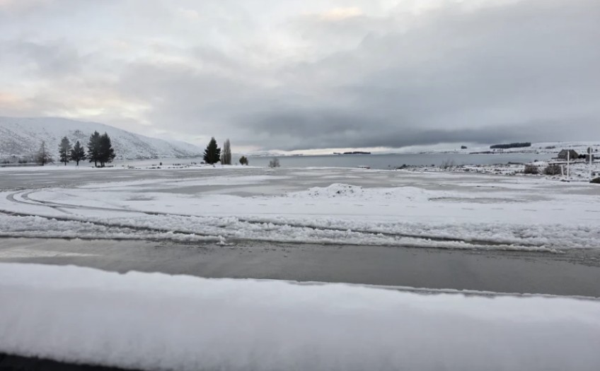
Main Image: Lake Tekapo has already been hit by heavy snow this week. Photo: Supplied / Tanja Clauberg


TOP STORIES