Heavy rain on the way for Westland, Otago headwaters
 Share
Share
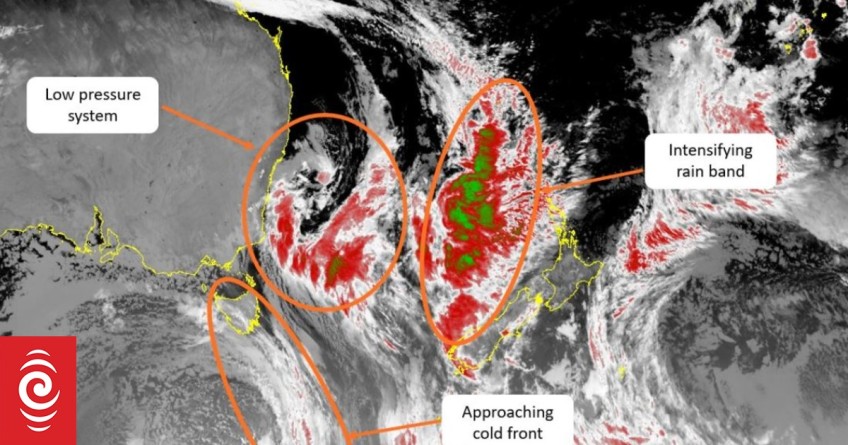
MetService is warning of more "intense bursts" of rain, high winds and thunderstorms across much of the country, including areas already sodden by recent rain.
The warm, wet weather of the past week has moved west but is due back across the country on Tuesday, bringing more heavy rain to northern and western areas as it tracks slowly to the east.
Orange heavy rain warnings are in place for Westland, the headwaters of the Canterbury lakes, the rivers around and south of Arthur's Pass, and Fiordland (north of Doubtful Sound).
Heavy rain watches are in place for Northland, Auckland, Great Barrier, Coromandel, North Taranaki, Tasman, Marlborough, Buller, and the headwaters of the Otago lakes and rivers.
MetService communications meteorologist John Law told Morning Report the weather system was likely to affect many of the same areas which had already seen a lot of rain in recent days.
The West Coast could see another 300mm of rain, over the next day or so, he warned, but Nelson, Tasman and possibly even parts of the Bay of Plenty could also be hit again.
"That's a fairly huge amount of rainfall on top of what we've seen in the last few days."
The weather meant there was risk of surface flooding and possibly more slips in some areas, he said.
"There could be some thunderstorms mixed in with it as well, so some pretty intense and heavy bursts of rain coming through."
Law said the current weather was being driven by sub-tropical air being dragged in from the north but a cold snap was predicted later in the week.
"We've been so warm over the last week or so ... we've had really mild temperatures the last few weeks or so, however things are changing."
He said once the current system pulled away to the east, the winds would change from a northerly to a southerly which would drop temperatures across the country, possibly bringing snowfall to some higher South Island altitudes.
There would be "a real contrast in those temperatures at the start of the week, compared to the end", he said.
Westland on standby
West Coast authorities are preparing for the expected heavy rain, with Westland mayor Helen Lash telling Morning Report the potential for slips was a particular concern.
"We've got massive catchments to every river area in Westland and South Westland in particular and if you get that heavy rain up there, that's going to exacerbate what's falling at the coastal area as well," she said.
"It's all compounding and it can become very, very problematic very, very quickly."
"Everybody's on standby, everybody has been called in to work through this, all agencies are meeting."
Lash said the New Zealand Defence Force had resources and staff on standby in Christchurch should they be needed to help the district, and neighbouring regions were on alert too.
"The word's got out to the communities and we will keep getting that word out to communities through the day and our advisement will be for people to only travel if absolutely essential, but preferably stay off the road when this rain comes."
She said bridges in the district appeared to have held up well in recent weather events but the potential for land movement was a concern.
"It's the slips that'll be the problem for us, they'll come down and they'll come down quickly; they'll come down with a lot of debris and they'll potentially close the roads."


TOP STORIES