Roads closed, power out as wild weather hits
 Share
Share
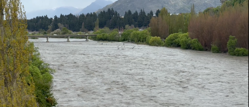
Wild weather has caused power outages and road closures in the district and flooding is still expected.
An Emergency Operations Centre has been established to co-ordinate preparations for and any responses required to localised flooding.
MetService's Heavy Rain Warning ended at midday today. The wind warning remains in place until 3pm and there are snowfall warnings from 6pm to 11pm on Crown Range Road and Lindis Pass. As of 1.20pm, the following roads are closed due to flooding:
- SH6 (Haast Pass) between Makarora and Haast.
- Mount Aspiring Road after the Treble Cone turn-off.
- Glenorchy-Paradise Road at the Rees River Bridge.
- Rees Valley Road north of Glenorchy.
- Glenorchy-Queenstown Road at One Mile
- Moke Lake Road at RP 3.17 (i.e. third cattlestop)
All major rivers have peaked but remain elevated and lake levels of Lake Whakatipu and Lake Wānaka are expected to peak in the early hours of Friday morning.
Lake Whakatipu is forecast to peak at 311.4m which is likely to flood low-lying lakefront areas in Kingston and the Queenstown waterfront. Stormwater systems in Queenstown Bay will also likely start backing up. Strong onshore winds are likely to cause wave run-up and significant driftwood debris around the Queenstown Bay foreshore and Earnslaw Park areas, Queenstown Lakes District Council says.
Lake Wānaka is forecast to peak at 279.5m causing flooding around the foreshore but it is not expected to flow across Ardmore Street.
Glenorchy Lagoon is forecast to peak at 312.6 m late Thursday/early Friday resulting in localised flooding to the north-west of the township and around the foreshore area.
ORC’s General Manager Science and Resilience Tom Dyer cautioned that while many rivers were now receding around the Queenstown Lakes area, further rain forecast for later today could prompt some rivers to rise again.
The Dart River peaked late Thursday morning at a flow of 2080 m3/s. This is the second-highest flow in the monitoring record for the ‘Dart at the Hillocks’ site, since monitoring commenced in June 1996.
QLDC will be making sandbags available at the Queenstown waterfront and Kingston as a first priority from mid-afternoon today. This is a precautionary measure for businesses and homeowners who wish to use them.
The council is supplying sand and sandbags to businesses and homeowners as a precautionary measure.
The Aurora Energy website is showing power outages around the district including one affecting about 460 homes in Glenorchy as of 2pm. Power is also out for about 200 customers at Arthurs Point and 260 near Gibbston.
Earlier, Otago Regional Council warned there could be extensive flooding in parts of Glenorchy.
In an update today, Dyer said there was potential surface flooding and localised ponding in low-lying areas of Beach St, Rees St, Marine Parade, Church St, Earl St, as water entered through the stormwater system, with reports of precautionary sandbagging underway.
Low lying parts of Kingston township were expected to flood, while in Glenorchy the outlook remained unchanged. The Glenorchy lagoon is predicted to overtop the Glenorchy floodbank, and flooding of the Northwest part of the township was still likely later this evening.
For much of Otago, severe gale northwesterlies were expected during the day with damaging gusts of 130 km/h in exposed places, up until about 4pm.


TOP STORIES