Flood warning issued for Glenorchy, Queenstown
 Share
Share
Otago Regional Council is warning that forecast wind and rain could cause extensive flooding in parts of Glenorchy.
MetService has issued a heavy rain warning for the Otago headwaters – between 140mm to 200mm of rain - from 1am Thursday through to about noon Thursday, in addition to a strong Northwest wind warning which affects most of Otago.
ORC’s general manager science and resilience Tom Dyer says there is "strong potential for high lake levels this week, as further periods of significant heavy rain follow the heavy rainfall experienced in the last few days”.
He says the council is actively monitoring lakes and rivers in the Queenstown Lakes area and there is likelihood of flooding in some areas from now and throughout the long weekend.
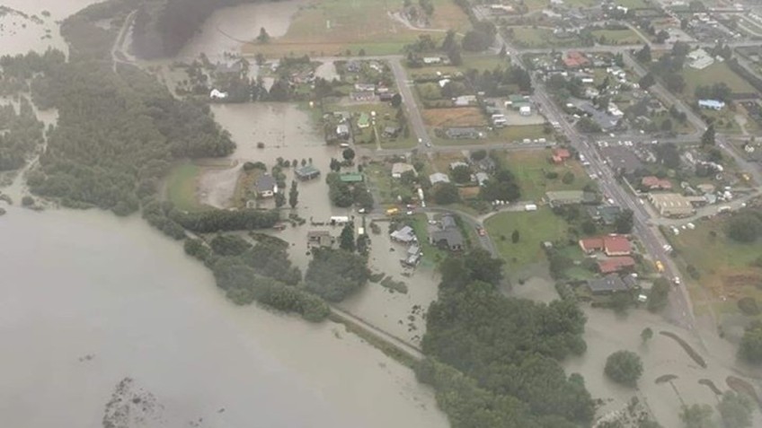
Extensive flooding is expected in parts of Glenorchy.
"It’s likely there could be extensive flooding of the Northwest part of the township similar to what occurred in February 2020," Dyer says.
Some flooding is also expected in low-lying Queenstown streets in the vicinity of Lake Wakatipu; such as low-lying sections of Beach St, Rees St, Marine Parade, Church St and Earl St where a depth of approximately 300-400mm is likely, low lying areas of Kingston; low-lying sections of Cornwall St where a depth of approximately 200-300mm is likely, and across the foreshores of Wanaka.
Strong winds are also forecast, which may cause waves and floating debris to impact the shoreline or water levels. The strong Northwest winds are expected later turn Southwest, the latter predominantly affecting the Clutha district.
Landsliding or debris flows triggered by high rainfall totals or intensities may occur on steep slopes, depending on the intensities, totals and location of rainfall and thunderstorm activity, in particular in the Makarora area (e.g. Pipson Creek, Muddy Creek), and at catchments on the Queenstown-Glenorchy Road.
Downstream in the Clutha catchment, it is expected that the Clutha River flow at Balclutha will remain elevated; but at less than 2000 cumecs for the rest of the week. There are no concerns about ORC’s flood protection schemes in Alexandra and Balclutha handling the expected flows downstream.
People in the vicinity of the river need to be aware of the possibility for the flow to rapidly increase because of high rainfall in the headwaters, regardless of the local weather.
The regional council's environmental data portal has real-time monitoring of rivers and lakes.
In February 2020 the Rees River burst its banks following a day of torrential rain. Houses were evacuated and the Glenorchy rugby grounds and golf course flooded.


TOP STORIES