Canterbury flooding: Christchurch roads closed by waters
 Share
Share
The Heathcote River in Christchurch has broken its banks and local authorities are warning that the next high tide will bring fresh flooding in the city.
MetService has a code-red warning in place - its highest alert level - for Canterbury as the deluge is expected to bring up to 400mm to the high country by late Monday morning.
The rain has begun to cut some areas off and make roads impassable, and those living near Ashburton in particular have been being advised to keep a close eye on the situation and monitor updates. A state of emergency has already been declared in the area.
Follow all the latest updates with RNZ's live blog
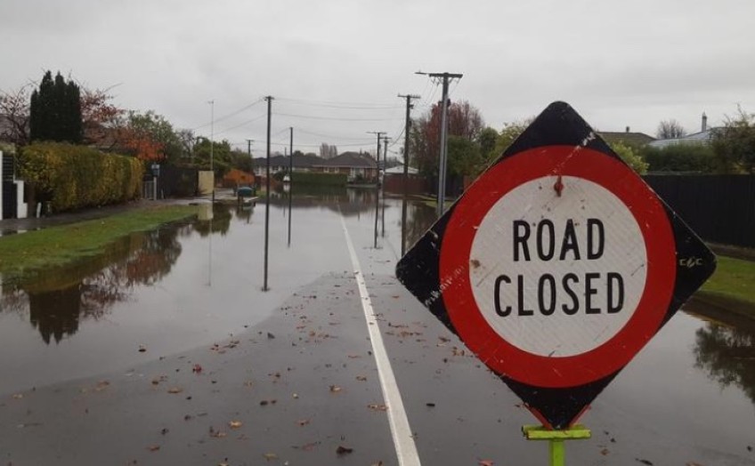
The Heathcote River in Christchurch has broken its banks by Clarendon Terrace, and a number of streets in central Christchurch are closed due to severe flooding.
In a statement this morning, the Council said most of the roads that have closed this morning are likely to remain closed until the high tides have passed tomorrow.
"So if you normally travel these routes to get to work or school, please start thinking about alternative ways of travel.'"
High tide on Monday morning is due at 8.30am.
If you have witnessed flooding and would like to share pictures or video with us, please email it to: [email protected]
The council is also urging people to drive slowly if they need to be out on the road, so that water is not pushed onto people's properties.
People are advised to avoid walking or biking through surface water as there is a chance it could be contaminated with wastewater.
Christchurch City Council spokesperson Tim Drennan said flooding was likely to ease over the coming hours as the tide recedes but that next high tide will bring fresh flooding.
"Most of the flooding that we've had so far has been related to the king tides.
"High tide for this morning has passed and we expect to see the flooding situation ease. However, with the next high tide due at 8pm we expect to see flooding occurring again. If people have vehicles parked in areas affected by flooding this morning, we advise they move them this afternoon before the next high tide.
Up to 8am this morning, Christchurch and the Port Hills have received between 40 and 60mm of rain. Parts of Banks Peninsula have received close to 100mm. Rain is expected to continue falling throughout today and tomorrow.
Catchments near Ashburton record record levels
Ashburton has activated its Civil Defence emergency operation centre, and residents have been asked to boil their water.
Town council spokesperson Reuben Garcia said the Ashburton River could breach its banks at Bixby Bridge or at Anama Valetta Road.
At this stage no evacuations have been ordered, but Garcia said contractors were out assessing the damage and residents were asked not to venture out today.
The Canterbury regional council's flood controller, Shaun McCracken, said by Sunday morning the situation was the most severe in the mid Canterbury, Ashburton and Hinds River areas, particularly at Ashburton Forks and Thompson's Track.
Rivers in the upper part of those catchments were flowing very high, with gauges recording some of the highest volumes ever, and more rain coming down.
"We're already seeing water out of the rivers over roads, so there's places that are already starting to be cut off and bridges that can't be used.
"We're expecting to see more overflow throughout the day as all that water starts moving down the catchment system. And if those gauges are true, they are going to be pushing the design capacity of the flood-protection scheme as it moves down the system.
"In particular, that's the north and south branches of the Ashburton [River]; the tributaries, the main ones being Taylor's Stream and Bowyer's Stream."
McCracken said field staff were observing the rivers and his team was in touch with Civil Defence crews.
A flooding warning on Marine Parade in North Brighton in Christchurch. Photo: RNZ / Rachel Graham
People should monitor their situation, and if they saw something that did not look right, "make safe decisions" he said.
The Ashburton District Council has warned people in the Methven and Mount Somers areas to boil water used for drinking, food preparation and hygiene purposes.
Deputy Mayor Liz McMillan urged people to stay home and keep safe. She said the council was sending updates through text messages and posts on its Facebook page.
More rain coming for Canterbury
MetService forecaster William Nepe said 100 to 150 mm of rain had fallen at weather stations in the foothills and high country, and: "We can expect another 100 to 150, possibly more in some places particularly about the foothills and high country to around midday Monday."
A warning has also been issued for severe gale southeasterlies today on the Canterbury coast, north of Ashburton.
Christchurch, the eastern plains and coastal areas of Canterbury are forecast to receive between 100 and 140mm of rain during the three-day deluge.
Photo: Environment Canterbury Regional Council
Canterbury south of the Rangitata River
Flooding is expected south of the Rangitata River in low parts of Geraldine near the Orari River, in the Arowhenua area, and between Geraldine and Temuka, including around the Hae Hae Te Moana and Kakahu rivers, the Canterbury regional council said.
Overnight significant amounts of rain fell in the area - between 150 and 180mm.
By 9am, the Orari River was flowing about 500 cubic metres per second, and still rising, and the rivers around the Temuka area were within capacity, but being closely monitored.
Selwyn District
The Selwyn District Council is urging people on the Springfield, Arthur's Pass, Hororata, Malvern Hills and Malvern Hills Dalethorpe to conservere water supplies.
Water is unable to be drawn safely, so the water supply has been shut to these areas.
Power cuts to homes
Surface flooding in Christchurch has knocked out power to hundreds of homes throughout the morning.
About 240 homes around Bishopdale went dark just before 5.30am this morning but it was restored later in the morning.
Close to 80 homes in Woolston spent the night without electricity but have had it restored this morning. And more than 2000 homes near Lake Ellesmere were briefly without power around 2am.
Further inland, about 80 homes went dark around Springfield at 4am.
Trees down and road closures
A Fire and Emergency spokesperson said they received calls reporting flooding on roads overnight, particularly on roads next to Christchurch's rivers, and near rivers on the Canterbury Plains.
They have also been dealing with downed trees, and expect to get more calls about damaged trees.
State Highway 73 from Springfield to Castle Hill in Canterbury was closed due to slips and flooding, NZTA Waka Kotahi said in a tweet.
State Highway 79 between Fairlie and Geraldine has also been closed, people are urged to use State Highway 8 as a detour.
UPDATE 8:15AMSH79 Fairlie to Geraldine is now CLOSED due to flooding. Please use an alternative route to detour. SH73 Springfield to Castle Hill remains CLOSED due to slips. Please continue to DELAY your journey. ^AL pic.twitter.com/L3IeoDI11M
— Waka Kotahi NZTA Canterbury & West Coast (@WakaKotahiCWC) May 29, 2021
Motorists have been asked to delay travel between Christchurch and the West Coast, as the SH73 closure means a long detour via SH1 and SH7.
Flood alert communications
Canterbury can sign up for free official flood alerts from the Canterbury regional council, including evacuation notices, by texting the name of their local river to 3730. Eg: text RANGITATA, or SELWYN to 3730 for updates about each river - the name of the river must be typed in uppercase letters. The other rivers for which these alerts are available, are: ASHBURTON, HINDS, PAREORA, RAKAIA, WAIHAO, WAIMAKARIRI, and WAITAKI.


TOP STORIES