Lakes under watch, still to peak as clean up begins
 Share
Share
Following heavy rain Lakes Whakatipu and Wānaka and Glenorchy Lagoon remain under watch and are expected to peak by tomorrow morning – but at the lower end of earlier predictions.
On Thursday night, MetService lifted its southern orange heavy rain and wind warnings, and red wind warnings, after the heavy rainfall in the Otago headwaters eased early earlier in the afternoon.
Otago Regional Council's General Manager Science and Resilience Tom Dyer says the flows of most Otago rivers peaked on Thursday morning, and lake level rises had now slowed.
“Some rain remains in the Otago forecast for today, it’s below the MetService watch and warning criteria, but due to current conditions, we’ll continue to monitor all river and lake flows and the lower Clutha catchment, including through the long weekend."
Dyer cautions that lake levels have the potential to increase further from the forecast rain on Monday, depending on the nature of the event, but it’s too early to quantify the extent.
Lake Whakatipu is predicted to remain steady or increase slightly with levels predicted to reach 311.1m-311.3m on Saturday morning. It’s expected Lake Whakatipu will begin to inundate Rees and Beach streets through the stormwater system when the lake level is about 311.3m. Precautionary sandbagging is already in place along parts of the foreshore.
Lake Wānaka is predicted to remain steady or increase slightly with levels predicted to reach 279.2m-279.4m on Saturday morning, with some inundation of the lake reserve land expected. This predicted lake level is about 600mm lower than the lower sections of nearby Ardmore Street.
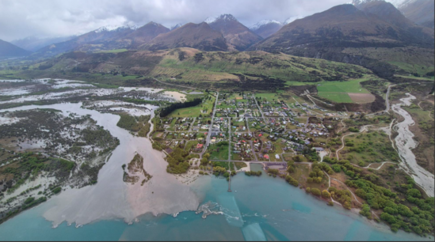
The level of Glenorchy Lagoon is predicted to increase again late tonight/early Saturday morning, but the level is not likely to exceed the overtopping threshold of the Glenorchy floodbank.
“However, some low-lying parts of Glenorchy, and also Kingston township foreshore, could begin to be affected,” Dyer says.
Queenstown Lakes District Council is supporting the community of Kingston at the southern end of Lake Whakatipu, as it remains without power and has limited cellphone coverage.
An Emergency Operations Centre has been set up by QLDC and Emergency Management Otago and centre Controller Bill Nicoll said the lack of power was having a greater effect on Kingston residents than it would elsewhere in the district given the township’s reliance on the Powernet electricity network.
“Household water supply is pumped from bores, so we’re working closely with the Community Resilience Group to make sure Kingston residents have access to clean water, temporary power from generators, and portaloos,” he said.
“We recognise that Kingston’s main electricity provider PowerNet is, in its own words, ‘overwhelmed’ with outages across their network and are asking that customers only call if there are downed lines or trees across lines.”
“We’ll continue to do all we can to support residents in our district’s southernmost township until mains power and cellphone coverage is restored,” Nicoll said.
Queenstown Lakes District Mayor-Elect John Glover visited Kingston this morning to talk with residents and see conditions for himself.
Speaking about the last 24 hours he said: “I'd like to recognise and thank all the Community Resilience Groups for their care locally, the multi-agency team that came together to run the EOC, and the unseen 'boffins' from agencies such as Otago Regional Council and NIWA who have really helped us understand and track this flood event.”
“I recognise the impact in terms of staff time and anxiety that all of this is having on our local businesses, and I hope you are all able to make the most of this holiday weekend.”
Sandbags provided by QLDC and its contractors that several Queenstown lakefront businesses installed as a precaution are now being removed, and clean-up of large amounts of driftwood washed up onto the foreshore in Queenstown, Wānaka, Glenorchy and elsewhere by strong winds is underway.
MetService forecasts for Monday show low confidence of significant heavy rain about eastern and Central Otago and Canterbury and low confidence of heavy snow down to 500 metres for Central Otago and the Canterbury high country.
Main image: Glenorchy township, about 2pm yesterday, about an hour before the Glenorchy lagoon peak. Credit: Jono Young/ORC


TOP STORIES