

Five diverse environmental reports tabled
Five diverse environmental reports have been delivered by ORC staff, including papers on threatened reptile species, kelp forest monitoring, the mapping of significant marine ecological areas and land and soil science mapping.
The fifth is a policy report, acknowledging the recently released Our Freshwater 2023 report by the Ministry for the Environment and Stats NZ, and how it works in with ORC planning.
All five reports are for ORC’s Environmental Science and Policy Committee.
Our Freshwater 2023 report outlined to ORC
The release of Our Freshwater 2023 earlier this month is timely for the ORC’s work currently being undertaken on the proposed Land and Water Regional Plan for Otago.
ORC’s Acting Principal Planner, Peter Constantine, says in the report summary that it examines the most pressing issues in Aotearoa New Zealand’s lakes, rivers, streams, wetlands and aquifers.
The report brings together peer reviewed published studies, mātauranga Māori and data from environmental indicators.
“Overall, the findings in Our Freshwater 2023 are a salutary reminder to the reader that while there is ongoing good work being done to improve the quality and management of Aotearoa New Zealand’s freshwater resources, there is much work still to do,” Mr Constantine says.
Threatened/at risk reptile species
A report by ORC Scientist – Biodiversity, Dr Scott Jarvie, entitled, Regional Threat Lists for Species in Otago, gives an overview of regional threat classification, including examples from other regions.
The report also includes details of the first regional conservation status undertaken for a group; in this case reptiles, for the Otago region, Dr Jarvie says.
There are a total of 34 reptile species identified in Otago; including 18 skinks, 13 geckos, two sea turtles and tuatara (the latter being a reintroduced population at Orokonui Ecosanctuary).
Dr Jarvie notes that 31 of the Otago species were assessed as “regionally threatened” or “regionally at risk”.
The recognition of regionally threatened species elsewhere has resulted in mitigation proposals; such as funding for pest control, conservation, or biodiversity management programmes, identifying priority sites or site restoration programmes.
He says regional threat assessments for other species groups will continue, as part of ORC’s biodiversity work programme.
On-going kelp forest monitoring programme
ORC’s Coastal Scientist, Dr Sam Thomas, says his report Kelp Forest Phase Monitoring Project is “phase 1” of a multi-year programme to gather baseline knowledge and provide guidance for on-going monitoring of Otago’s coastal marine ecosystems.
The report will provide a baseline of the distribution of Macrocystis kelp around Otago, to determine the next phase of monitoring and inform the review of ORC’s Regional Plan: Coast, which is proposed to start in 2024-25 and be notified in 2025-26.
Dr Thomas says kelp forest support some of the highest levels of biodiversity; supporting marine food-webs, recreational, commercial and cultural fisheries, while also having values in their potential for pharmaceutical, carbon capture and nutritional uses.
In the report Dr Thomas notes there is anecdotal evidence of a reduction in Macrocystis kelp forests around Otago. While globally, marine heatwaves are a major stressor to kelp forests, local stressors such as sediment entering the coastal waters have also been shown to exacerbate the consequences of climatic events on the kelp forests.
Mapping of significant marine ecological areas
ORC’s Coastal Scientist, Dr Sam Thomas, says his report Marine Significant Ecological Areas Spatial Mapping Project, is to provide information on a project completed by NIWA to map significant ecological areas within Otago coastal marine area.
The mapping will be used to inform ORC’s review of its Regional Plan: Coast for Otago, and assist in on-going monitoring programme, including key habitats and ecosystems along the coast.
Significant ecological areas were identified, with those areas split into management classes, including reef fish, seabirds, marine mammals and land, Mr Thomas says.
However, several gaps of some ecological features and geographic areas were identified, including intertidal benthic invertebrates, reef fish, marine mammals and seafloor geomorphic features, he said.
The project’s next steps include a management framework for the marine, significant ecological areas, and more derailed coastal monitoring programme.
Land and soil science mapping
In the report Land Science Update, ORC’s Team Leader - Land, Dr Ben Mackey, says the science team has for the past two years been rebuilding capability in land and soil science, focussing on mapping and quantifying land use and developing programmes to improve soil mapping and monitoring.
Dr Mackey says the “key workstreams” are land use, nitrogen mapping, expanding soil mapping around Otago and developing soil health and moisture monitoring networks.
The ongoing work programme for land science has a dual focus, to inform development of the ORC’s proposed Land and Water Regional Plan, and to establish monitoring programmes for environmental management over decades ahead.
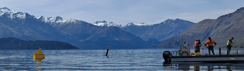
Main image (supplied/ORC): Deployment of a water monitoring buoy by ORC staff last year on Lake Wānaka


TOP STORIES